


Mozilla Stumbler

Perihal Mozilla Stumbler
Mozilla is a nonprofit project and global community building a better internet. Mozilla Stumbler is an open-source wireless network scanner that collects GPS data for the Mozilla Location Service, our crowd-sourced location database. As you move around, the app "stumbles" upon new Wi-Fi networks and cell towers. The Mozilla Location Service combines these wireless network measurements to provide geolocation services for Firefox and other open source projects. For more information, visit our project page:
• https://location.services.mozilla.com
How to use Mozilla Stumbler
• The app stops/pauses automatically when you are not moving or your battery is low. (This feature works better on newer devices as they have better sensors).
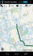
• Go to un-stumbled areas (not covered in blue) to fill in the coverage map: https://location.services.mozilla.com/map
• Improve the accuracy of the service by stumbling in the blue areas.
• Try walking, biking, or driving new routes with Mozilla Stumbler every day!
• Start with major streets and intersections, then explore smaller streets.
• Your contributions will take a day to show up on the coverage map.
Feedback
• Please report bugs on GitHub: https://github.com/mozilla/MozStumbler/issues
• or the #geo IRC channel on https://wiki.mozilla.org/IRC
To conserve cellular data usage, the Stumbler's map view only shows high resolution map tiles on Wi-Fi. In the Settings, you can change this to always show the high resolution maps,
License
• Mozilla Stumbler is open-source software. The code is available on GitHub: https://github.com/mozilla/MozStumbler
Mozilla adalah projek bukan keuntungan dan masyarakat global membina internet yang lebih baik. Mozilla Stumbler adalah sumber terbuka pengimbas rangkaian wayarles yang mengumpul data GPS bagi Mozilla Lokasi Perkhidmatan , pangkalan data lokasi orang ramai-sumber kami. Seperti yang anda bergerak, app "tersandung" apabila rangkaian Wi-Fi baru dan menara sel. The Mozilla Lokasi Perkhidmatan menggabungkan kedua-ukuran rangkaian wayarles untuk menyediakan perkhidmatan geolokasi untuk Firefox dan projek sumber terbuka yang lain. Untuk maklumat lanjut, sila layari laman projek kami:
& Bull; https://location.services.mozilla.com
Bagaimana untuk menggunakan Mozilla Stumbler
& Bull; Berhenti app / jeda secara automatik apabila anda tidak bergerak atau bateri anda rendah. (Ciri ini berfungsi lebih baik pada peranti yang lebih baru kerana mereka mempunyai sensor yang lebih baik).
& Bull; Pergi ke kawasan un-tersandung (tidak dilindungi dengan warna biru) untuk mengisi dalam peta liputan: https://location.services.mozilla.com/map
& Bull; Meningkatkan ketepatan perkhidmatan itu dengan penghalang di kawasan biru.
& Bull; Cuba berjalan, berbasikal, atau memandu laluan yang baru dengan Mozilla Stumbler setiap hari!
& Bull; Mula dengan jalan-jalan utama dan persimpangan, kemudian meneroka jalan-jalan yang lebih kecil.
& Bull; Sumbangan anda akan mengambil masa sehari untuk dipaparkan di peta liputan.
Maklum Balas
& Bull; Sila laporkan bug pada GitHub: https://github.com/mozilla/MozStumbler/issues
& Bull; atau saluran IRC #geo pada https://wiki.mozilla.org/IRC
Untuk menjimatkan penggunaan data selular, paparan peta Stumbler hanya menunjukkan resolusi tinggi jubin peta pada Wi-Fi. Dalam bahagian Tetapan , anda boleh menukar ini untuk sentiasa menunjukkan peta resolusi tinggi,
Lesen
& Bull; Mozilla Stumbler adalah perisian sumber terbuka. Kod ini boleh didapati di GitHub: https://github.com/mozilla/MozStumbler
Mozilla Stumbler - Versi 1.8.8
(15-02-2019)
Mozilla Stumbler - Maklumat APK
Versi APK: 1.8.8Pakej: org.mozilla.mozstumblerVersi Terkini Mozilla Stumbler


Aplikasi dalam kategori sama

Anda juga mungkin suka...


